
अंतरराष्ट्रीय जैव विविधता दिवस: पर्यावरण में बदलाव से बढ़ रही चिंता
हर साल 22 मई को जैव विविधता की महत्ता लोगों को समझाने के लिए जैव विविधता दिवस (International Biodiversity Day) मनाया जाता…
Read More → हर साल 22 मई को जैव विविधता की महत्ता लोगों को समझाने के लिए जैव विविधता दिवस (International Biodiversity Day) मनाया जाता…
Read More →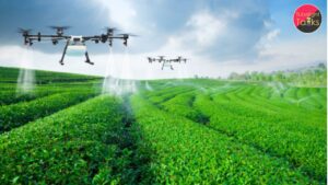
Precision Agriculture in India: India is known as an agricultural country, with agriculture being the backbone of its economy. Precision agriculture provides…
Read More →
जब कोई शिशु जन्म लेता है, तो वह इस पृथ्वी पर सांस लेना शुरू करता है और शुद्ध ऑक्सीजन प्राप्त करता है,…
Read More →
अक्सर जब जीवन में परिस्थितियाँ बदलती हैं और कठिन समय आता है, तो उससे बाहर निकलने के लिए सकारात्मक विचारों की आवश्यकता…
Read More →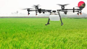
With the increasing demand for sustainable agriculture, remote sensing technology has emerged as a powerful tool for soil mapping, classification, and evaluation.…
Read More →
In the digital era, social media has emerged as a powerful yet dangerous tool for sharing and circulating content. While considering its…
Read More →
Making your home a smart home does not have to be costly. With some planning and the use of low-cost devices, you…
Read More →
Self-discipline, as the term defines itself appropriately, the ability to maintain discipline in various life aspects by yourself, is termed as self-discipline.…
Read More →
Listening is an underrated yet a profound life-skill. Not only does it form the basis for other life-skills, but also prepares you…
Read More →
शब्द शक्ति का अर्थ है वाणी और भाषा की शक्ति, जो न केवल विचारों और भावनाओं को व्यक्त करने का माध्यम है,…
Read More →