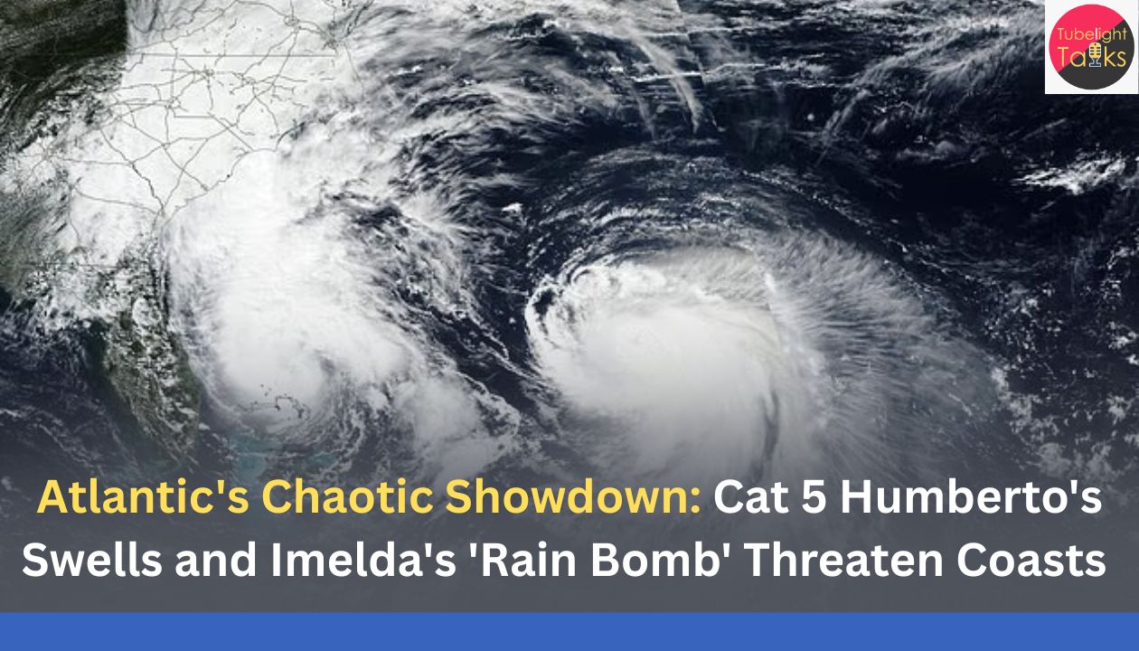
Atlantic’s Chaotic Showdown: Cat 5 Humberto’s Swells and Imelda’s ‘Rain Bomb’ Threaten Coasts
Atlantic’s Chaotic Showdown Cat 5: The Atlantic hurricane basin has forcefully emerged from a period of unusual calm, exploding with a trio of tropical systems that are forcing emergency management officials across the Caribbean and the eastern United States to raise alarm. This sudden burst features a powerful Category 5 hurricane, a strengthening tropical storm, and a developing depression that have created an exceptionally complicated and high-stakes scenario for millions.
The surge in cyclonic activity, occurring well after the climatological peak on September 10, aligns with expert forecasts from NOAA and Colorado State University. These experts noted that shifting wind patterns and conducive atmospheric factors were likely to support a noticeable uptick in development continuing into early October, a trend demonstrated last year when late September and early October proved devastatingly active. Forecasters note that while the climatological peak has passed, roughly 60% of tropical activity typically occurs after September 10, with two-thirds of all Atlantic activity historically occurring between August 20 and October 10.
The complexity of the current setup, featuring Hurricane Humberto, Tropical Storm Jerry, and Potential Tropical Storm Imelda, is testing the limits of meteorological prediction and requiring swift action from emergency management teams.
Humberto’s Raw Power: Atlantic’s Chaotic Showdown Cat 5
Hurricane Humberto has been the definition of a powerhouse, demonstrating explosive strengthening to reach the peak Category 5 status, with maximum sustained winds of $160$ mph. This rapid intensification, which saw its wind speeds increase by $80$ mph in just 24 hours, cements its place as the second Category 5 storm of the 2025 season.
While the massive storm is tracking safely out in the open Atlantic, avoiding direct landfall on the U.S. mainland, its immense scale is dictating weather conditions across vast distances. Its influence is felt acutely along the coastline:
- Coastal Danger: Massive swells generated by Humberto are already affecting the U.S. East Coast.
- Rip Currents: Forecasters with the NWS warn that these swells will likely cause life-threatening surf and rip current conditions beginning this week along impacted beaches.
- Historical Echoes: This type of destructive surf has a real-world impact, with similar activity from Humberto and Imelda having already been cited in the collapse of multiple coastal homes in North Carolina’s Outer Banks.
Though no coastal watches or warnings were in effect for the U.S. from Humberto itself, the enduring danger of its energy demands continued caution from beachgoers and coastal residents.
Tropical Storm Jerry: The Next Threat to the Caribbean
Simultaneously, Tropical Storm Jerry is rapidly advancing westward, targeting the Leeward Islands. As the 10th named storm of the season, Jerry has begun a gradual strengthening process and is forecast by the NHC to reach hurricane status by late Friday or Saturday. The next name on the list for a forming tropical storm is Humberto, and the one after that is Imelda.
Jerry’s core was located about 100 miles east of the northern Leeward Islands late Thursday, moving west-northwest. Warnings and watches are currently in effect for portions of the Caribbean chain, which includes Anguilla, Barbuda, Sint Maarten, St. Barthelemy, and St. Martin, as well as watches for Antigua, Montserrat, Nevis, Saba, St. Eustatius, St. Kitts, and Guadeloupe.
The immediate threats expected as Jerry passes nearby include:
- Torrential Rainfall: Two to four inches of rain, with local storm totals possibly reaching six inches, are expected across the Leeward and Virgin Islands.
- Flash Flooding Risk: This amount of precipitation brings a tangible risk of flash flooding, especially in urban areas and those with steep terrain.
- Dangerous Swells: The storm is also generating swells that are beginning to reach the Leeward and Windward Islands. These swells will spread westward, reaching the Virgin Islands and Puerto Rico tonight, before moving toward the rest of the Greater Antilles, posing a risk of life-threatening surf and rip currents.
Jerry’s development, along with the other systems, underscores the increasing odds of tropical development across the Atlantic basin that NOAA’s Climate Prediction Center had anticipated.
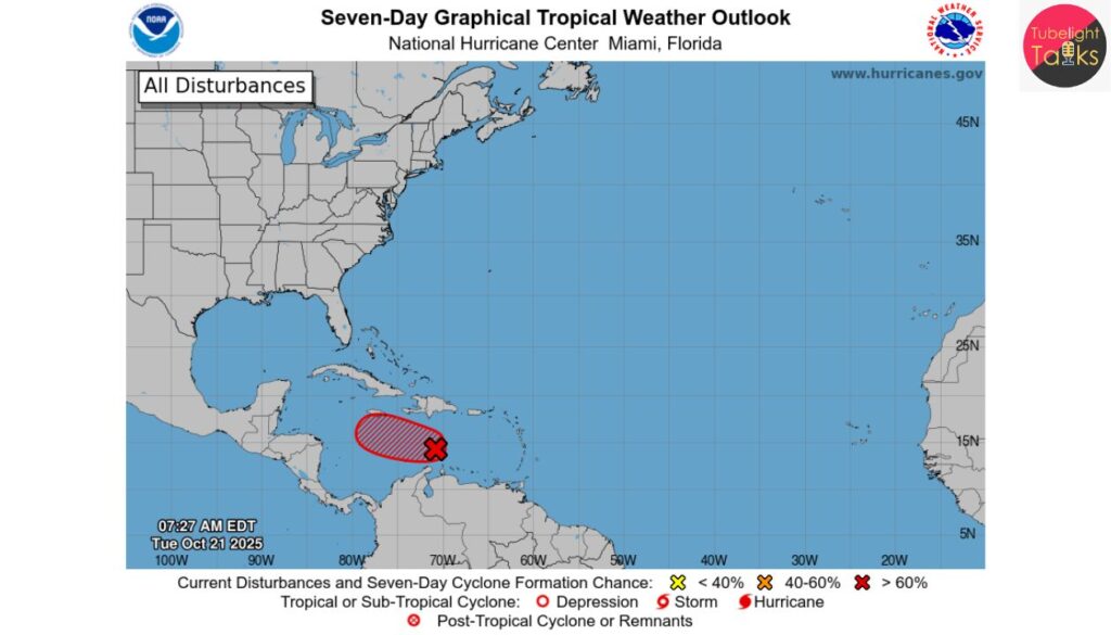
Imelda and the Unpredictable Flood Catastrophe
The most significant potential human-impact threat to the continental U.S. stems from the developing system expected to become Tropical Storm Imelda. Currently located several hundred miles east of the Lesser Antilles, its forecast is marred by complexity and a dire flooding prognosis. The NHC has indicated that a tropical depression is likely to form by mid to late week from this system.
The official NHC track calls for the new system, once named Imelda, to strengthen and possibly reach hurricane intensity off the Florida coast early next week. The gravest danger is tied to a forecast model showing the storm could slow and weaken as it approaches the South Carolina coast, spending nearly 24 hours in virtually the same offshore location.
NHC Director Michael Brennan warned that this slow-moving scenario makes heavy rain the “significant threat,” cautioning that this would be in addition to existing heavy rain across the region.
The severe threats to the Southeast include:
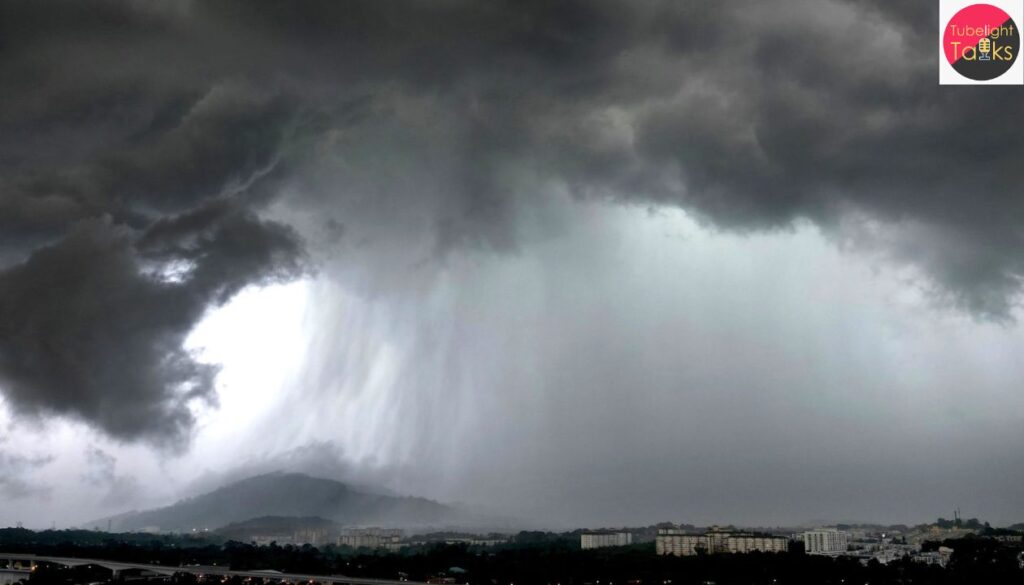
- Catastrophic Rainfall: AccuWeather meteorologists are forecasting that the Carolina coasts could see upward of $8$ to $16$ inches of rain, while $2$ to $4$ inches could fall from far eastern Georgia to central Virginia.
- Widespread Flooding: This rainfall magnitude, forecasters state, can lead to widespread life-threatening flooding, especially if the storm slows down or stalls.
- High Alert Status: Brennan stressed that “everybody along the coast of South Carolina, North Carolina, from Georgia, all the way up into the southern mid-Atlantic states is going to want to pay attention to the forecast for this system as we go throughout the weekend.”
The Chaotic Science: Storm-on-Storm Interaction
Adding to the complexity, meteorologists are grappling with the rare possibility of a Fujiwhara Effect interaction between the two cyclones, Humberto and Imelda.
The Fujiwhara Effect is a phenomenon where two storms close enough to each other—a separation distance of roughly 800 miles being a rule of thumb—begin to spin around a common center point. The potential for this interaction, which could cause one storm to absorb another, the two to merge, or both to move off in different directions, has been hinted at for days by computer models.
Given Humberto is “so much larger and stronger,” experts suggest that the centroid of the rotation would be much closer to Humberto’s center. This could mean Imelda “feel[s] a significant tug and even get slingshot out to sea before reaching the coast.”
This potential “tug-of-war” introduces greater uncertainty than normal, forcing the NHC to schedule increased flights over the western Atlantic by hurricane hunter aircraft and launch additional weather balloons to gather better data on the systems and their surrounding environment.
Precursor Risk: Ground is Already Saturated
The flooding threat posed by Imelda is magnified because the southeastern U.S. is already dealing with saturated soil from an unrelated Predecessor Rain Event (PRE). This weather pattern, which occurs well ahead of a tropical system, is characterized by tropical air flowing into a frontal zone, triggering heavy rainfall.
This setup, worsened by a nearby upper-level low-pressure area, has already resulted in severe issues:
- Infrastructure Failure: The Gatlinburg Bypass in Tennessee is currently closed due to a landslide caused by flash floods related to this heavy rainfall, demonstrating the pre-existing vulnerability.
- Heightened Danger: The heavy rain already soaking the Appalachians and Southeast means the arrival of Imelda’s moisture will lead to a greater potential for flooding even before the storm proper moves in, setting up a dangerous confluence of weather factors.
Raed Also: Climate Tipping Point Crossed
A Spiritual Call for Stewardship: The Unique Knowledge of Sant Rampal Ji Maharaj
The rapid breakdown of Earth’s ecosystems and the escalating severity of natural warnings, like these hurricanes, raise profound spiritual questions. According to the unique knowledge of Sant Rampal Ji Maharaj, true dharma is defined by right action (satkarm), rooted in truth and compassion, not mere ritual.
When humanity acts out of greed and neglects the planet, it violates the moral order. The scriptures teach that Earth is a sacred trust. Ignoring nature’s warnings, as we see with dying coral reefs, leads to irreversible loss. The path to restoration requires an inner transformation—a shift from exploitation to stewardship, simplicity, and universal service—marking this crisis as a definitive call for spiritual awakening.
The Mandate for Sustained Vigilance
The current surge in the Atlantic, driven by two hurricanes and one strengthening storm, underscores the need for continuous public awareness. With the late season proving its capacity for high-impact, potentially devastating threats—and two major systems currently engaging in a complex atmospheric dance—residents across the entire eastern seaboard and the Caribbean cannot afford complacency. The risks from intense wind, life-threatening surf, and potentially catastrophic rainfall require that all emergency plans are finalized and official advisories followed without delay. The window for preparation is closing rapidly as these three storms continue their unpredictable paths across the basin.
FAQs on the Atlantic Storm Threat
1. What are the three major systems being monitored?
Major Hurricane Humberto (Cat 5), strengthening Tropical Storm Jerry, and potential Tropical Storm Imelda.
2. Where is Jerry threatening right now?
The northern Leeward Islands with flash flooding from $2$ to $6$ inches of rain and dangerous surf.
3. What is the greatest risk from Imelda?
Catastrophic inland flooding for the U.S. Southeast (Georgia/Carolinas) if the storm stalls offshore.
4. What is the “Fujiwhara Effect” in this context?
A rare interaction where the stronger Humberto could “slingshot” the path of Imelda, causing extreme forecast uncertainty.
6. Did Hurricane Humberto make U.S. landfall?
No, but its size generates life-threatening swells and rip currents all along the U.S. East Coast.
Related Stories


Discussion (0)