Oil Slick off Kharg Island: Satellite Images Detect Suspected Spill Near Iran’s Primary Export Hub
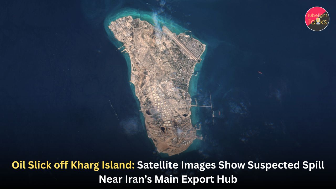
Satellite imagery has detected a suspected oil slick spreading near Iran’s Kharg Island, the country’s main crude export hub in the Persian Gulf. Images captured between May 6 and May 8 by Europe’s Copernicus Sentinel satellites showed a grey-and-white slick west of the island, covering dozens of square kilometres of sea. The source and cause of the apparent spill remain unclear, and neither Iranian nor U.S. authorities had issued detailed public comments on the finding at the time of reporting.
The development comes amid heightened U.S.-Iran tensions, a naval blockade, disrupted tanker movement and fears over the environmental cost of conflict in the Gulf. Kharg Island is central to Iran’s oil-export system, making the suspected slick both an ecological and strategic concern.
Kharg Island Oil Slick: What Satellite Images Show
Grey-and-White Slick Seen West of the Island
The suspected oil slick was detected through satellite imagery taken between May 6 and May 8. Reuters reported that images from Copernicus Sentinel-1, Sentinel-2 and Sentinel-3 satellites showed a likely spill west of Kharg Island, an island roughly eight kilometres long and positioned at the heart of Iran’s oil-export infrastructure. The slick appeared visually consistent with oil and covered a large area of water, with different estimates placing it at dozens of square kilometres.
RTHK, citing AFP and satellite-analysis estimates, reported that the slick appeared to cover more than 52 square kilometres as of Thursday and was spreading southward toward Saudi waters. This southward movement increases concern because oil pollution does not respect maritime boundaries. A spill near one country’s export terminal can become a regional marine problem if currents, winds and tides carry it across the Gulf.
The fact that the slick was visible from space underlines its scale. Small leaks are often difficult to detect clearly in satellite images. A surface stain visible across multiple satellite passes suggests a serious pollution event, even if the exact volume remains uncertain.
Source of the Spill Still Unknown
At present, the cause remains unclear. Reports say no active continuing leak was visible in newer images, meaning the suspected spill may have come from a past discharge, tanker movement, damaged infrastructure, pipeline release or another maritime incident. Experts have not publicly confirmed one single source.
This uncertainty is important. In a conflict zone, people may quickly assume sabotage, military damage or tanker attack. But oil slicks can also result from operational discharges, aging infrastructure, ship-to-ship transfers, pipeline leaks, tanker damage or emergency dumping. Investigators need more evidence before assigning responsibility.
Also Read: Crisis in the Strait of Hormuz: Can Iran’s “Ceasefire First” Plan Save the Global Oil Market?
Why Kharg Island Matters
Iran’s Main Oil Export Hub
Kharg Island is not an ordinary coastal location. It has Iran’s largest oil terminal, oil pipelines, storage tanks and related export infrastructure. Several reports describe it as handling nearly 90% of Iran’s crude exports, much of which is destined for China.
This makes any pollution event near Kharg strategically sensitive. If the slick is linked to infrastructure stress, tanker congestion or conflict-related disruption, it could signal broader risks to Iran’s export system. If it is unrelated to direct military action, it still highlights how fragile oil operations become when maritime traffic, storage and shipping are under pressure.
A Hub Under Regional Pressure
The suspected slick comes during a period of extreme tension in the Gulf. The United States has imposed a naval blockade on Iranian ports, U.S. and Iranian forces have exchanged fire, and shipping through the Strait of Hormuz has been disrupted. Kharg Island sits north of the strategic Strait of Hormuz and is deeply connected to the same oil-export system that global markets are watching closely.
When oil infrastructure operates under conflict pressure, risks multiply. Tankers may wait longer, transfer operations may become more complicated, maintenance may be delayed, and military activity can increase danger around ports and terminals.
Environmental Concerns in the Persian Gulf
Marine Life at Risk
Oil slicks can harm marine ecosystems in several ways. Oil can coat fish, seabirds, marine mammals and shoreline habitats. It can reduce oxygen exchange, contaminate plankton, affect coral and seagrass, and introduce toxic compounds into food chains. The Persian Gulf is already environmentally stressed by heat, heavy shipping, industrial activity and coastal development.
Even if a spill remains offshore, it can still affect marine life. Fish larvae, plankton and surface-feeding species are vulnerable. Birds that land on contaminated water can lose insulation and buoyancy. If oil reaches coastlines, cleanup becomes more difficult and expensive.
Potential Threat to Regional Waters
The report that the slick appeared to be moving southward toward Saudi waters adds a diplomatic and ecological dimension. If pollution crosses maritime boundaries, neighbouring countries may demand explanations, monitoring and cleanup cooperation.
Oil spills in semi-enclosed seas like the Gulf can become especially serious because water circulation is limited compared with open oceans. Pollution may remain in the regional marine environment longer, affecting fisheries, desalination plants, coastal habitats and port operations.
Energy Security and Market Anxiety
Oil Pollution Meets Oil Politics
The suspected spill is not only an environmental story. It is also an energy-security story. Kharg Island is a key export point for Iranian crude. Any sign of trouble near the island can raise questions about whether oil exports, tanker loading, storage or infrastructure integrity are at risk.
Energy markets are already sensitive because of U.S.-Iran tensions and the uncertain status of shipping through the Strait of Hormuz. If oil pollution is linked to damaged infrastructure or conflict-related disruption, traders may price in higher risk. Even if the slick is later found to be limited, uncertainty itself can affect markets.
Shipping and Insurance Concerns
Shipping firms and insurers watch oil-spill reports carefully. A polluted area near a major terminal can complicate navigation, loading operations, liability exposure and port access. If a tanker is suspected of causing a spill, insurance and legal consequences may follow. If infrastructure is suspected, operators may face pressure to inspect pipelines, storage systems and loading facilities.
In a conflict zone, these questions become harder to answer quickly. Access may be limited, governments may withhold information, and commercial operators may hesitate to disclose details.
Possible Causes Under Review
Infrastructure Stress
Kharg Island’s oil infrastructure includes pipelines, storage tanks and terminal facilities. Aging infrastructure can develop leaks, especially under heavy operational pressure or reduced maintenance conditions. If wartime disruption has strained normal operations, risk may increase.
Tanker Congestion or Transfers
Another possible source is tanker activity. If many vessels are delayed, rerouted or used for storage, the risk of accidental discharge or operational spill can rise. Reuters reported that the slick appeared near Iran’s main oil hub during a period of heavy regional disruption and blockade pressure.
Conflict-Related Damage
Given the broader U.S.-Iran crisis, conflict-related damage cannot be ruled out without investigation. However, responsible reporting must avoid declaring a cause before evidence is available. At present, reports say the source is unknown.
Also read: OPEC+ Moves to Stabilize Markets with Planned Oil Output Increase
Why Satellite Monitoring Matters
Space-Based Environmental Evidence
Satellite imagery has become essential for detecting oil spills, especially in conflict zones where direct access may be limited. Radar satellites can detect changes in sea-surface texture because oil smooths waves and creates distinctive patterns. Optical satellites can show visible slicks when cloud conditions allow.
The Kharg Island case shows how satellite monitoring can reveal environmental damage even when governments or operators remain silent. Copernicus Sentinel satellites provide regular imagery that researchers and journalists can use to assess pollution, shipping and infrastructure events.
Independent Verification Is Crucial
In wartime, official statements may be delayed, incomplete or political. Satellite evidence helps independent analysts identify what is happening on the ground or at sea. It does not answer every question, but it creates a factual starting point.
For oil spills, satellite monitoring can estimate surface area, track movement, detect possible active sources and guide cleanup response. It can also help hold responsible parties accountable.
What Authorities Should Do Next
Confirm the Source
The first priority is identifying the source. Authorities need to examine terminal infrastructure, tanker movements, pipeline status, ship-tracking data, weather patterns and satellite sequences. Without source identification, cleanup and accountability remain weak.
Assess Environmental Damage
Environmental teams should assess the slick’s thickness, oil type, movement and risk to marine habitats. If the slick approaches sensitive areas, containment and response plans should be activated.
Inform Neighbouring States
If the slick is moving toward regional waters, affected countries should receive transparent updates. Oil pollution can create cross-border environmental damage, so regional cooperation is essential.
Protect Cleanup Workers
If cleanup begins, workers must be protected from toxic exposure. Oil-spill response requires trained teams, protective gear, safe disposal methods and clear coordination.
Gulf Conflict and Environmental Cost
War Damages More Than Military Targets
The suspected Kharg slick reminds the world that conflict does not only damage armies and infrastructure. It damages water, air, wildlife, fisheries, public health and future generations. Environmental harm often remains long after missiles stop.
Oil pollution is especially painful because it comes from the same energy system on which modern economies depend. The world wants oil for transport, industry and power, but when oil spills into the sea, the cost is borne by fishers, coastal communities, birds, marine life and ecosystems that cannot speak for themselves.
Environmental Security Is National Security
Countries often treat environmental damage as secondary to military and economic concerns. That is a mistake. A polluted sea can damage food systems, water security, tourism, livelihoods and public health. In the Gulf, desalination plants are especially important because many countries depend on them for drinking water. Oil pollution near coastal or intake areas can create serious operational concerns.
Pollution, Greed and the Spiritual Lesson of Responsibility
The suspected oil slick near Kharg Island shows how human greed, conflict and careless use of natural resources can stain even the sea. JagatguruRampalJi.org explains that Sant Rampal Ji Maharaj is working to eliminate social evils through True Spiritual Knowledge and to create a clean society by removing corruption, intoxication, violence, greed and other harmful conduct.
Its World Wildlife Day resource also identifies pollution and unsustainable exploitation of natural resources as major threats to living beings. In relation to this oil slick, the SatGyaan message is clear: environmental crises are not only technical failures; they are also moral failures when humans value power and profit above life. Sant Rampal Ji Maharaj’s teachings guide people toward truth, compassion, non-violence, self-restraint and true devotion to Supreme God Kabir.
If human conduct becomes pure, society will naturally protect water, wildlife, air and future generations instead of destroying them for temporary gain.
FAQs on Oil Slick off Kharg Island
1. Where was the suspected oil slick detected?
The suspected oil slick was detected west of Iran’s Kharg Island in the Persian Gulf, near the country’s main oil export hub.
2. How large is the slick?
Different estimates describe it as covering dozens of square kilometres. One report cited an estimate of more than 52 square kilometres as of Thursday.
3. What caused the oil slick?
The cause remains unclear. Possible explanations include infrastructure leakage, tanker activity, operational discharge or conflict-related damage, but no final cause has been confirmed.
4. Why is Kharg Island important?
Kharg Island hosts Iran’s largest oil terminal, pipelines, storage tanks and related export infrastructure. It handles a major share of Iran’s crude exports.
5. Why is the spill environmentally concerning?
Oil slicks can harm marine life, birds, fisheries, coastal ecosystems and possibly regional waters if currents carry pollution beyond the immediate area.
6. How was the slick detected?
The slick was identified through satellite imagery from Europe’s Copernicus Sentinel satellites between May 6 and May 8.
Related Stories


Discussion (0)